
Newsroom
By Andreas Hadjikyriakou
The CIA was drafting scenarios for the geographic separation of Greeks and Turks in Cyprus as early as 1964. These plans, ranging from relocating Turkish Cypriots to Turkey to exchanges of populations and territories with Greece, were meticulously considered. However, the most feasible plans involved the internal movement of populations within Cyprus itself, deemed worthy of "serious study." Although one of these plans materialized in 1974, it unfolded under far less favorable circumstances for Greek Cypriots.
In May 1964, a mere two months after UNIFCYP's deployment to Cyprus, the CIA's deputy director tasked the agency's geographic unit with assessing potential separation plans for Greek and Turkish Cypriots. This assessment likely played a pivotal role in shaping the subsequent Acheson Plan (from Dean Acheson, Former United States Secretary of State) presented to Cyprus, Greece, and Turkey later that summer.
The CIA's 29-page, classified report outlined seven scenarios, three focusing on relocating Turkish Cypriots out of Cyprus and four on internal population movements. Remarkably, the study, conducted in 1964, utilized computers for land use calculations. While the political solution was left unspecified in the partition scenarios, it was assumed that British bases would be retained.
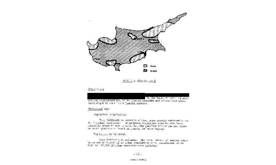
Scenario A envisaged the creation, within Cyprus, of six separate, unconnected areas "that could be considered Turkish cantons".
Scenario 1
The first scenario, titled "Resettlement of Turkish Cypriots in Turkey for financial incentives," proposed the relocation of 104,320 Turkish Cypriots (based on the 1960 census). This plan aimed to alter Cyprus's demographic makeup to predominantly Greek, potentially leading to either independence or union with Greece. However, crucial details such as the relocation destination within Turkey, financial terms, funding sources, and potential repercussions for the Greek minority in Turkey were not addressed.
Scholars highlighted several drawbacks of Scenario 1, including the adverse economic impact on Turkey. The previous large-scale population movement in Turkey, involving approximately 150,000 Turkish refugees from Bulgaria in 1951-53, had led to significant economic challenges. These challenges included widespread unemployment and underemployment, stemming from the country's struggle to generate sufficient economic opportunities to accommodate population growth. Additionally, it was predicted that the resettlement plan would likely result in a decline in living standards for Turkish Cypriots.
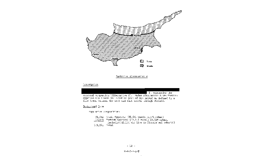
"Partition: Scenario B" is, roughly, the situation created after the Turkish invasion in 1974.
Scenario 2
The second scenario, dubbed "Exchange of Turkish ownership of part of Cyprus with Thrace," proposed a territorial swap between Turkey and Greece, involving the concession of the Evros region to Turkey and Cyprus to Greece. This plan also entailed the relocation of Turkish Cypriots and Thracians to their respective newly assigned territories. However, the study identified significant drawbacks, primarily concerning the substantial number of people affected by such an exchange.
According to the scenario, approximately 104,320 Turkish Cypriots and 247,016 Thracians would be relocated. The study also acknowledged the likelihood that some Thrace Greeks might need to relocate outside Cyprus, given the island's limited capacity to accommodate such a large population increase. Additionally, there was no land area comparison available, as scholars lacked information on the land holdings of Turks and Greeks in Thrace. In Cyprus, Turkish Cypriots owned 879 square kilometers of land.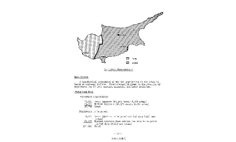
Scenario C divides Cyprus vertically, instead of horizontally as B and the division is "based on underground wealth".
Scenario 3
Titled "Exchange of Turkish ownership of part of Cyprus for the Aegean islands," Scenario 3 proposed a swap involving Turkish Cypriots and Aegean Greeks. This scenario raised the possibility of the Aegean islands being annexed to Turkey and Cyprus to Greece. Specifically, Scenario 3 focused on Lesvos, which encompasses 2,135 square kilometers and had a population of 154,795 in 1951. Additionally, the Dodecanese islands were considered, with mentions of them serving as a potential resettlement area for Turkish Cypriots. In 1951, the population of the Dodecanese comprised 105,687 Greeks and 15,792 Turks. Rhodes was also cited in this context.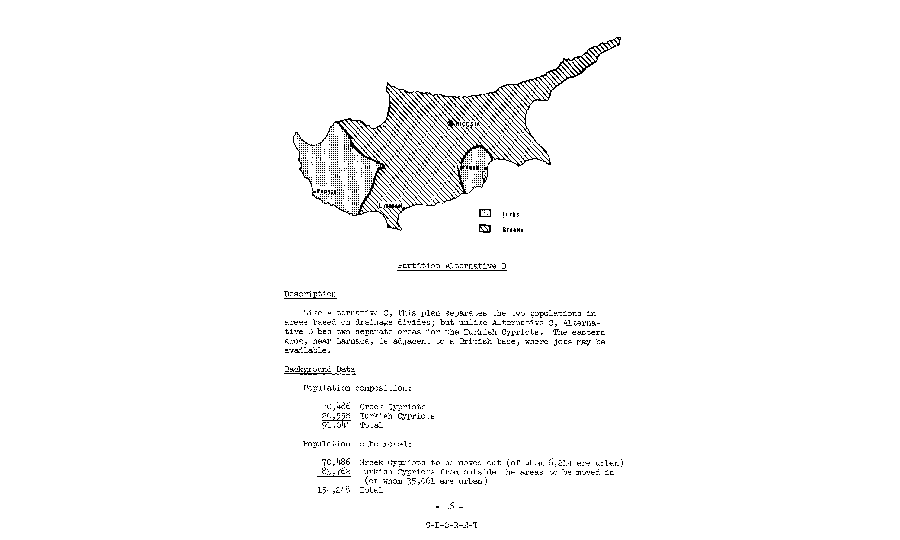
"Partition: Scenario D" divided the two populations into areas based on underground wealth, but unlike Scenario C, Scenario D has two separate areas for Turkish Cypriots.
Scenario 4
Entitled "Dichotomy: Scenario A," this scenario's initial two lines of description remain classified. It proposes the establishment of six separate, disconnected areas within Cyprus, akin to Turkish cantons. Estimating the population movements required is deemed "very difficult," with projections ranging from 80,000 to 198,000, depending on whether urban populations are considered. Politically, settling this plan is noted as highly challenging, with further undisclosed complexities. The presence of compact Turkish Cypriot enclaves amidst Greek Cypriot areas is anticipated to perpetuate existing tensions. Additionally, logistical challenges for Turkish Cypriots traveling between enclaves through Greek territories are predicted.
Scenario 5
"Partition: Scenario B" roughly mirrors the post-1974 situation following the Turkish invasion. Beyond the human tragedy inflicted by the invasion, the current territorial landscape is exacerbated compared to the 1964 scenario. Famagusta and Morphou were not initially included in the region designated for Turkish Cypriot relocation. Consequently, Turkish Cypriots are expanding their land ownership from 652,000 to 936,000 acres, likely acquiring additional irrigable land compared to their current holdings.
Scenario 6
Scenario C proposes a vertical division of Cyprus, contrasting with the horizontal division of Scenario B, and the division is based on underground wealth, considering population distribution, mineral, and water resources. Advantages of Scenario C include boundaries passing through sparsely populated areas, thereby reducing confrontation opportunities, and privately owned land areas aligning closer to land currently owned by Turkish Cypriots compared to Scenario B. However, disadvantages entail the Turkish region lacking a suitable port.
Scenario 7
Scenario D, termed "Partition," delineated areas for the two populations based on underground wealth. In contrast to Scenario C, Scenario D featured two distinct regions for Turkish Cypriots. The eastern area, close to Larnaka, abuts a British base, potentially offering employment opportunities, thus safeguarding British military interests irrespective of the outcome. The advantages highlighted include access to port facilities for Turkish Cypriots in Larnaka.
The CIA study also considered relocating Turkish Cypriots beyond the Mediterranean, possibly to Australia or Canada but acknowledged the complexities involved.
These scenarios, developed over half a century ago, provide insights into the intricate geopolitical calculations and human dilemmas surrounding the Cyprus conflict.
[This article was translated from its Greek original and edited fro clarity and brevity]


