
Newsroom
Heavy rainfall was observed in various areas of Cyprus on Wednesday afternoon (11/10). The Meteorological Service has issued a yellow warning for thunderstorms possibly accompanied by hail. This warning is in effect until 6:00 pm and has been in place since 11:00 am. Videos posted on the "Weather friends of Cyprus" page show that the areas affected so far are Nicosia and Limassol.
Video from the area of Dali:
Video from the area of Apesia
The situation on the roads
Due to heavy rainfall in the Nicosia district around 3.45 pm on Wednesday afternoon, there is an accumulation of water on the Nicosia-Lemesos motorway, at points between Tseriou - Idalios and Pera Choriou Nissou. This has made the road slippery and caused traffic congestion.
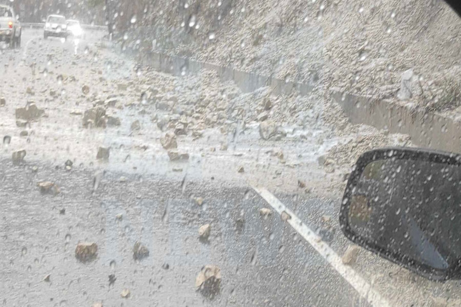
At the same time, due to the rains in the Limassol district, there have been rock and soil landslides in various places on the Paramytha - Gerasa road. Police are present in the area to provide assistance, and local authorities' crews have been called to clean the road.
Police recommend caution to passing drivers, advising them to drive their vehicles at a safe, low speed and maintain a safe distance from vehicles ahead.
The rest of the road network across the country is not experiencing any particular problems.
Power cuts in Limassol due to bad weather
According to Christina Papadopoulou, the press spokesperson of the AHK, dozens of areas in the Limassol region have experienced power outages due to the bad weather. The restoration of electricity supply may take 2-3 hours.
Detailed weather forecast
A weak low-pressure system is affecting the region, leading to unstable weather conditions.
In the afternoon, the weather will be partly cloudy, with local showers and isolated thunderstorms expected, mainly in western and southern mountainous areas, inland, and in the east. Hail is likely to fall in thunderstorms. Winds will be northeast to southeast and in the west southwest to northwest, light to moderate, 3 to 4 Beaufort, with variable winds in a thunderstorm. The sea will be calm to a little rough.
Tonight, the weather will be mainly clear, although later on, there may be patchy clouds, mainly on the east coast. Winds will be mainly west to northwest and locally up to northeast, light, 3 Beaufort, and the sea will be calm to slightly choppy. Temperatures will drop to around 17 degrees inland, around 19 on the coast, and around 11 degrees in the higher mountains.
Tomorrow, the weather will initially be mainly clear, but gradually increasing clouds will develop locally, and isolated showers or short isolated thunderstorms are expected, mainly in the mountains and inland. Winds will initially blow northwest to northeast, light, 3 Beaufort, becoming later mainly southwest to northwest, light to moderate, 3 to 4 Beaufort, and locally on the west coast moderate, 4 Beaufort. The sea will be calm to a little rough, but later becoming a little rough locally in the west. Temperatures will rise to around 31 degrees inland, around 29 degrees on the coast, and around 21 degrees in the higher mountains.
On Friday and Saturday, the weather will be mainly clear at first, but gradually clouds will develop, and isolated showers and isolated thunderstorms will occur, mainly in the mountains and inland. On Sunday, the weather will be mostly cloudy, with localized showers and isolated thunderstorms expected. The temperature is not expected to show any significant change until Saturday, remaining close to the average climatic values, while on Sunday, the temperature will drop.
This information is sourced from 24News


